Techblog: Outdoor Navigation with Garmin watches Epix 2 or Fenix 7 and Komoot

Using navigation on Garmin smart watches can be complicated because of multiple options and restrictions. This article describes briefly how I prepare planned hiking or bicycle tours with help of Komoot and Garmin Connect, both installed as App on an iPhone and on a Windows 10 desktop computer. A good and comprehensive introduction to the topic in German language can be found in the blog of Michael Hohenleitner on www.federweg.com.

Navigation on Garmin device

Garmin watches with GPS and feature to display maps, such as the models Epix 2 or Fenix 7, exhibit several grades to support navigation. They are in order of increasing comfort level:

  • Only map and position display: Just use the map with your current position and navigate manually.
  • Track and position display on map: Shows a track (in Garmin terminology „course“, in German „Strecke“) or a saved position on the map, together with the current position. On a course the distance to the destination is shown below the map. In case of deviations, the distance from the track is displayed.
  • Fixed course with turn by turn directions: During navigation, turn by turn directions are shown as small arrows below the map with track display and current position. Upcoming direction changes or deviations from the course can trigger an alert. Garmin can show besides the distance also the estimated arrival time for the destination.
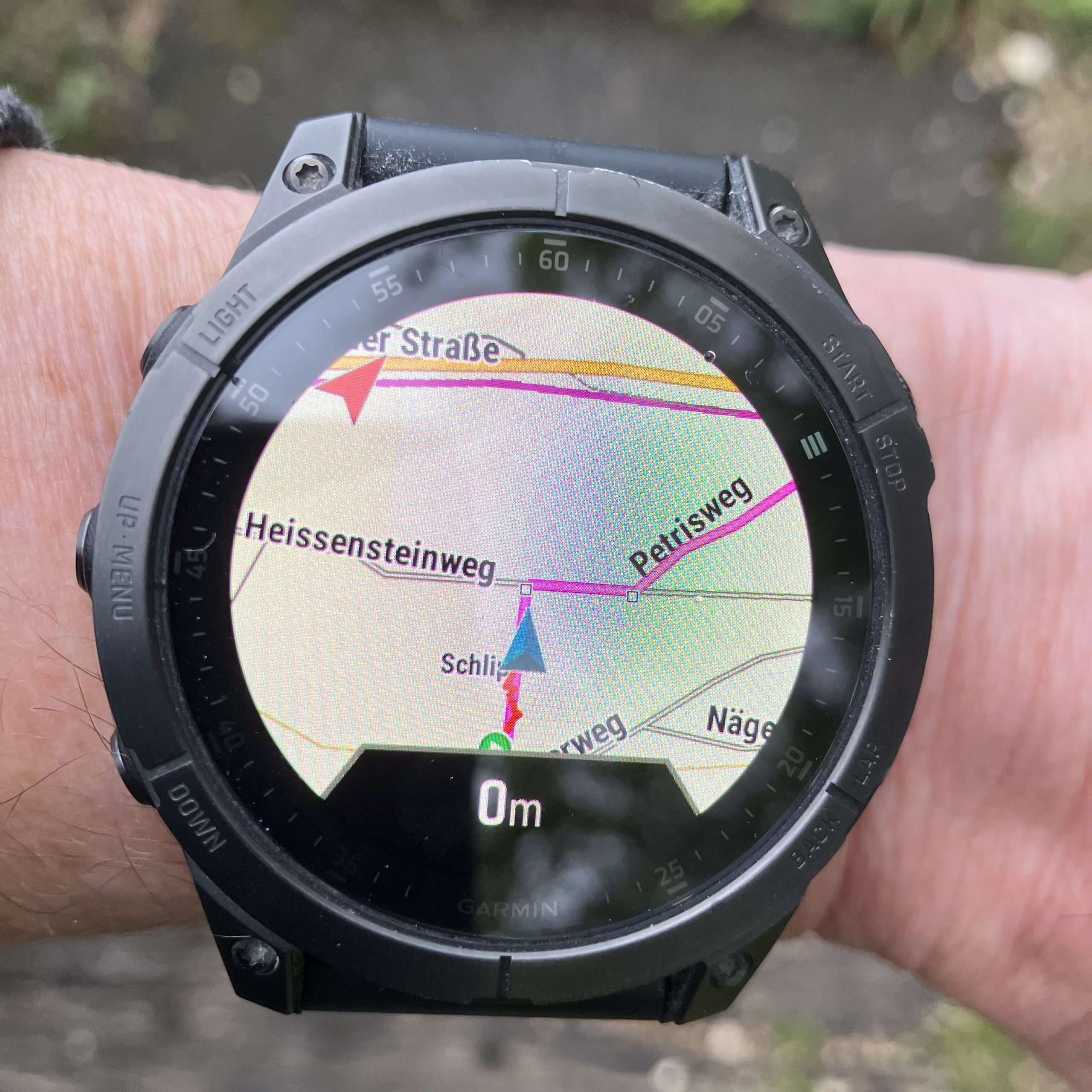
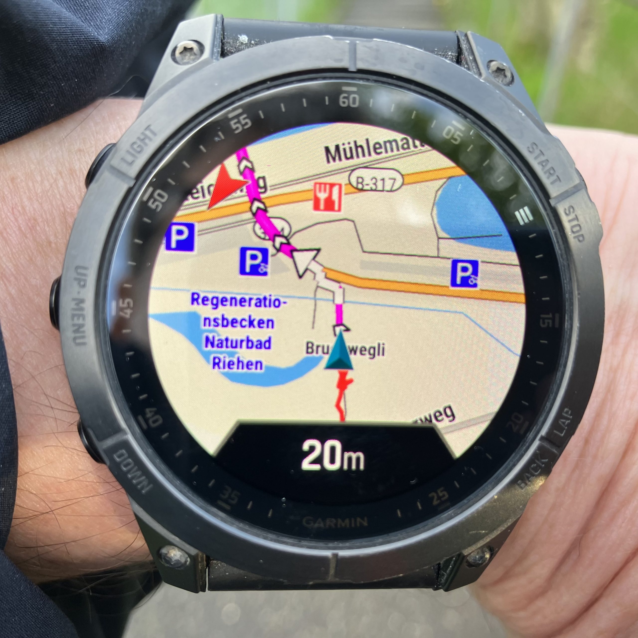
  • Dynamic navigation: The course to the chosen destination is dynamically calculated from the current position und turn by turn directions are directly displayed with arrows in the map, together with additional information such as street names.


Turn by turn directions for fixed courses can be only displayed for courses uploaded through Garmin Connect to the watch, but not for tracks or routes directly uploaded as GPX file (e.g. from Base Camp).

I should note that also Garmin Explore could be used instead of Garmin Connect to link the mobile Garmin device to the Garmin account, but Garmin Connect appears more functional and stable. Connecting to both in parallel could lead to non synchronized data or even to data loss according to some internet sources.

Dynamic navigation is only possible if the watch itself calculates the navigation. This has the benefit of highest comfort, but comes at the price of long calculation times especially for destinations more than 10 km away. If dynamic navigation is desired for a predefined course (Strecke), then the routing option for courses must be changed for the selected activity from „use course“ (Strecke verwenden) to „use map“ (Karte verwenden). This option works however only for courses uploaded with Garmin Connect. Dynamic navigation can navigate only along paths available in the Garmin maps, the option „use map“ can therefore lead to drastic variation from the originally intended course, especially if the original course contains off-grid sections or has been created with a specialized map. To follow the course strictly, the option „use course“ must be set. Navigation options can be individually set for each activity. I have chosen the setting „use course“ for sport activities such as hiking or cycling (where following exactly the intended track is the wish), and „use map“ for the activity Navigation (where reaching the destination in shortest time is the main focus).

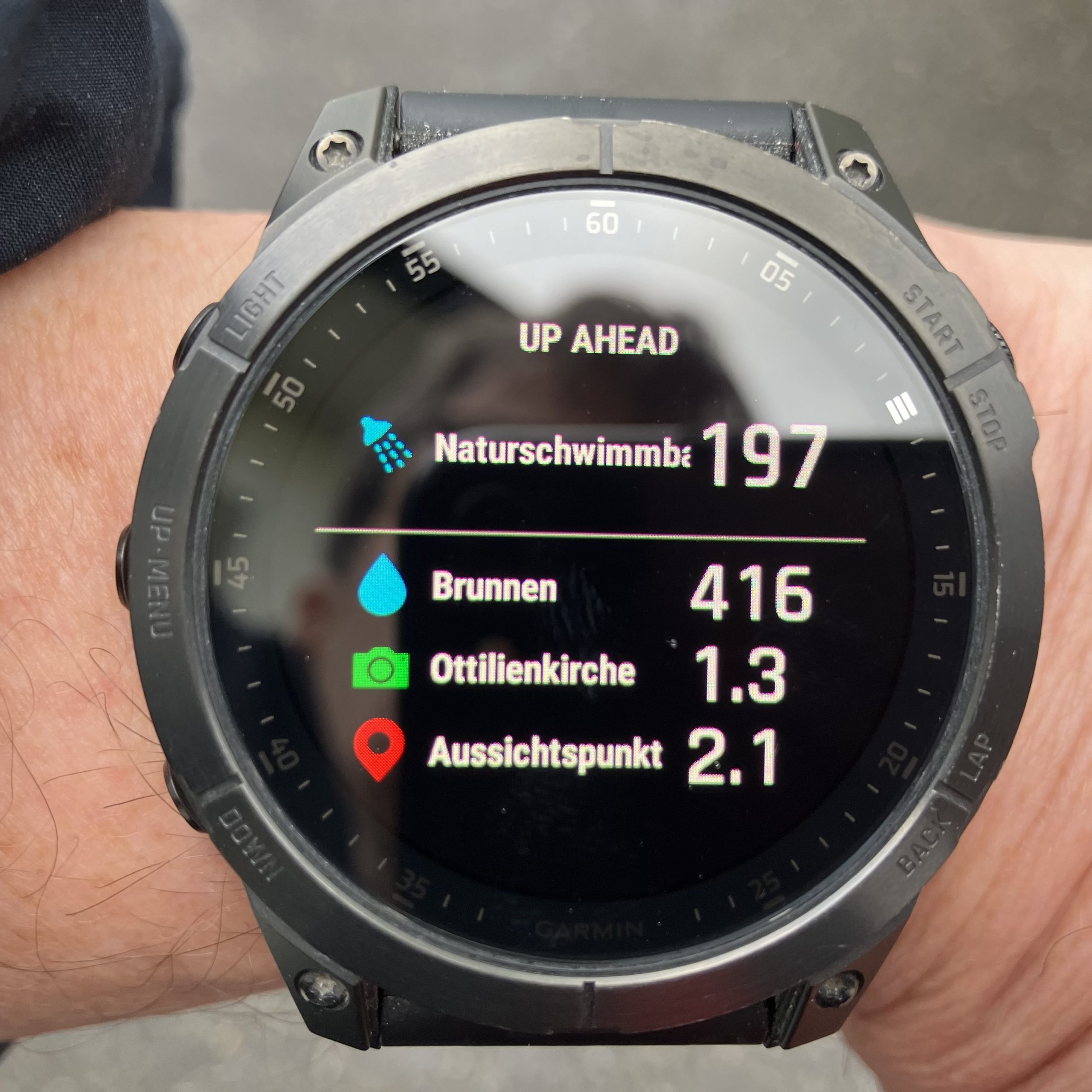
A nice feature on Garmin Epix 2 or Fenix 7 is the up-ahead screen during navigation. It displays a list with upcoming waypoints together with their distance from current location. This can make hikes more informative and entertaining (e.g. refreshment 1 km ahead) or supports sportive activities (e.g. sprint section starts in 300 m). The availability of the up-ahead function is unfortunately very limited, it can be only used for fixed courses where the waypoints to display in up-ahead are manually added with Garmin Connect, and then only with the navigation option „use course“. The up-ahead function is neither available for tracks not created and uploaded through Garmin Connect, nor during dynamic navigation, i.e. if the option „use map“ is set for navigation on a course. Interestingly (or annoying) are waypoints for courses created directly on the Garmin watch not displayed on the map or in up-ahead.

Integration of Komoot and Garmin

I prefer to do the planning of courses with Komoot. An account of Komoot can be connected to Garmin Connect. In this case, all courses planned in Komoot are synchronized to Garmin Connect and the Garmin watch, and all tracks recorded with the Garmin device are copied as completed tour to Komoot. The synchronization covers the track, its elevation profile and the duration, but unfortunately not the waypoints and other information, thus the up-ahead screen of the Garmin watch cannot be used. The Garmin device shows however the course on the map and turn by turn directions with arrows below the map. It is unfortunately not possibly to edit the imported course in Garmin Connect or to add waypoints (unless a copy, which is not synchronized with Komoot, is created). Another shortcoming is that after completion of the activity the tour is copied as plain track (without waypoints and other information) to Komoot under a different name and the original Komoot course (including waypoints and other information) remains as planned in Komoot, its status cannot be changed to completed.

Another option is to add the Komoot app to the Garmin mobile device through Garmin IQ. The app has been completely revamped in January 2023. It adds a Komoot screen accessible through the activities / favorites menue of the watch. From there you can view all planned tours or start a planned tour. The view contains details such as duration, elevation profile, difficulty level and path / underground types, but unfortunately no map. When starting the trip in the Komoot app on the watch, if offers the choices to use Garmin or Komoot for the navigation. Garmin shows the track on its map but without directions, Komoot shows direction arrows directly in a plot of the track but without a background map. Waypoints are not displayed in either option. And the tour remains in any case as planned in Komoot, the status cannot be changed to completed, even though the navigation has been completed and the activity has been saved. I find the Komoot app on Fenix 2 not really helpful and have removed it from the watch.

I use instead the following workaround with Komoot and the connected Garmin Connect account: I plan my tours normally in Komoot, which has better maps and planning information (difficulties, path type, underground type, points of interest, pictures) and offers easier and faster planning than doing it in Garmin Connect. Because I have connected my Komoot and Garmin accounts, the planned tours are synchronized to Garmin Connect and the watch. In case I want to include interesting waypoints in the navigation on a course created with Komoot and display them in the up-ahead screen, I prepare a copy in Garmin Connect and add the waypoints manually to this copy. The copy must be saved with a different name, I append typically „_WP“ (for waypoints) to the name from Komoot. The copy must be created in Garmin Connect, not directly on the Garmin watch. (Creating an editable copy of a course directly on the Garmin watch ignores original waypoints and adds a plentyfull of new waypoints, which are then all shown in up-ahead). If the course is later modified in Komoot, the entire procedure must be unfortunately repeated, or the modified course is used without waypoints and up-ahead display. After completion of the activity, it is automatically copied to Komoot as completed trip. In case the synchronization has failed, I download the completed tour as GPX file and upload it to Komoot; this can be only done within 4 weeks before it is automatically removed from Garmin Connect. Finally, I rename the completed trip in Komoot and delete then the planned tour.

Spectroscope

AstroMedia offers a plentiful choice of interesting and affordable, mainly cardboard based construction kits for scientific instruments with focus on astronomy. After assembling the refractor telescope for 30 Euro, my second project was the hand sprectroscope for 8 Euro.

The Fraunhofer lines (dark absorption lines in the sunlight spectrum) are difficult to see and even more difficult to photograph, but the following lines are observable with some exercise:

Line Cause Color wavelength (nm) display (nm)
G Fe blue 430.8 430
F H (β) blue 486.1 483
b Mg (triplet) green 517-518 517
E Fe green 527 526
D Na yellow 589-590 584
a O2 (terrene) red 628-629 619
C H (α) red 656.3 642
B O2 (terrene) red 686.7 660

Techblog: Automated email

Automated recurring email with Outlook (Office 365) without admin rights

Assume you meet with your friends on every first Wednesday in each month to play card games. And you want to send them an email reminder on the Monday before. For a similar purpose, I tried to set-up an automated recurring email with Outlook in Office 365. I had already sent automated emails easily from my private Ubuntu server. But the task was difficult in my office environment because of two issues. Firstly, Outlook has no ready available function for automated emails. And secondly, I am just ordinary user and have no admin authorization. 

I tried first the method described in the Microsoft documentation. This is designing a custom form with a VBA script in conjuction with a recurring Outlook task. But this method cannot be applied without an admin account, because running custom form scripts are since 2017 desabled by default and it requires setting registry keys to re-enable it. I also tried to realize the automated email with Microsoft Flow, but could not find a suitable template for that.

The path to success is a method which I found in a tutorial of  ExtendOffice.com. In the first step, a recurring appointment with reminder is created in the Outlook calendar. For this appointent, a new category must be used. I have named the category „Recurring email“. Finally, a short VBA script is created for the standard object „ThisOutlookSession“. Scripts for this object run automatically when Outlook starts. The script detects when the reminder for an appointment of the category „Recurring email“ is closed, composes then an email with the appointment title as email subject, the text string in appointment location as email recipients, and the appointment details as email body, and finally displays (VBA command: .display), or sends (VBA command: .send) this email.

It should be noted that VBA scripts are blocked in the default security settings of Office 365 unless the code is authorized by a self-signed digital certifcate.

Result and limitations:
When the reminder for the appointment pops up and is quit by hitting „dismiss“ or „dismiss all“, the email is either created and displayed for further edits ,or directly sent. But because the VBA script is running on the local device (e.g. a desktop computer), it works only if the local device is powered on with Outlook running. Otherwise, the sending is delayed until Outlook on the device has been started again, the missed appointment displays the reminder pop-up and is quit. It is not sufficient to access Outlook on a synchronized mobile phone or through a web interface, because the necessary VBA script is only available on the local device. I found no way to run the script on the Office 365 server, which would allow full automation without the need to have a local application running and to manually quit a reminder to trigger the email. Another issue is the limitation of the length for the appointment location entry to 255 characters, which is not sufficient for the „To:“ line in case of multiple email addresses. I could resolve this by using group email addresses, another option would be to modify the VBA script and record the email recipients in a structured way in the appointment details section. The latter would also allow emails with more attributes, such as different entries for „To:“, „Cc:“ and „Bcc:“. But despite of the above mentioned limitations, I found the current solution for automated recurring emails in Outlook helpful and have it in use.

The example mentioned at the beginning of this article is a little tricky. The card game evening is on the first Wednesday in each month, and the reminder email should be sent on the Monday before. But this is not necessarily the first Monday of the month. If the new month starts on a Tuesday or Wednesday, then the Monday before the first Wednesday is the 4th or 5th Monday of the previous month. Nevertheless, this can be realized with Outlook. The recurring appointment is scheduled for every first Wednesday in each month, and the reminder is set to 2 days prior to this appointment. Since the quitting of the reminder triggers the email, and not the appointment itself, the email will be sent on the correct day, even it is in the previous month.

Hiking tour in the Qinling mountains

I have been fascinated by the view of the Qinling mountain range (  秦岭 )approaching from the Wei river valley since I have first seen it in the year 1998. The visit of the Taoist temple Lou Guan Tai ( 楼观台寺 ) in that year is unforgettable for me, as it was remote, pristine and atmospheric (unfortunately the place has meanwhile developed to a major and commercial tourist spot). Since then, I have returned to that area, which is close to the hometown of my wife, every one or two years. But it took me until last week before I had the opportunity for a longer hike in that mountains.

View to Qin Ling mountains from Wei river valley

We did park the car at a restaurant after entering the Qinling mountains in a narrow valley on a small local road.

Trout served in a small restaurant in the Qin Ling mountains

The hike takes with breaks approximately 6 hours and is 10 km long (round trip), with 1100 m climbing up and down. The path is narrow and well visible, but not marked or signposted.

For those who want to do the same hike, here are the coordinates of major waypoints. If you want the GPX files, please drop me a short note.

N34 02.369 E108 32.579 Exit on Expressway G5 (Xi’an to Hanzhong), take road S107 towards West.

N34 03.887 E108 24.769 542 m Leave road S107 and turn South on narrow road into a mountain valley.

N33 59.962 E108 24.460 849 m Park car at restaurant, start of hiking. Direction is East-Southeast, first 50 m are stairs. The path is first following the small river and later steeply ascending the mountain ridge.

N33 59.395 E108 25.749 1738 m Small and lonely hiking path is merging with a more populated path coming from North (see comment later). Continue on that path uphill towards South until you reach the crest and continue on the crest further South. Don’t miss that turnoff on your way back.

N33 59.034 E108 25.695 1959 m Guanyin temple ( 观音山 )

N33 58.920 E108 25.553 1936 m End of path at another small temple. Go back the same way from here.

We were told that the Guanyin temple can be also reached, with less climbing, from a higher starting point which we had visited three days earlier. Both ways merge at the forking point mentioned above. I add here the coordinates for the alternative approach:

N34 03.595 E108 28.254 529 m Leave main road S107 here and drive on narrow road uphill.

N34 02.181 E108 27.304 934 m We left the car here and started hiking. The road continues however to the area of the next temple.

N34 02.255 E108 26.824 1115 m Temple

N34 02.353 E108 26.807 1104 m Another temple with nice view to Xi’an and the Wei river valley.

N34 01.418 E108 26.503 1203 m We stopped hiking here and turned back to the car; it should be possible to continue to the Guanyin temple from her.


Firmenlauf

Am 28. Juni findet der jährliche Firmenlauf in Basel statt. Ich hatte bisher zweimal teilgenommen, nämlich 2014 und. 2018. Beim ersten Mal erreichte ich Platz 1372 (38:14 für 6000 m), vier Jahre später reichte es immerhin für Platz 1371 (33:15 für 6000 m). Alles deutet also darauf hin, dass ich diesmal Platz 1370 haben werde. Ich werde dann nach dem Lauf berichten.

Nach dem Lauf: Leider war es an diesem Nachmittag noch sehr heiß, 30 Grad im Schatten. Vielleicht deshalb nur Platz 1491 mit 34:32 für 5900 m.

B2Run Basel 28th June 2019

Der nächste Lauf war coronabedingt erst am 3. Juni 2022. 36:25 hat zu Platz 1023 gereicht.

Quiz

What it the fragrant, but moderately toxic compound in this plant?

The picture has been taken on 6th April 2019 at the edge of a woods on the Sissacherfluh (700 m) near Basel. Author and license: Wolfgang Schäfer, own photograph, public domain.

I will post the answer in one week.

Answer: The plant is Galium Odoratum, or Sweetscented Bedstraw, German name is „Waldmeister“. It contains the active compound Coumarin (German: Kumarin), which gives not only this plant but some cinnamon varieties and also hay its characteristic smell. The plant is used as ingredient of May Wine (German: Maibowle). It is advisable to limit the quantity and to use only plants before flourishing, otherwise the too high coumarin concentration can cause head ache.

Structural formula of coumarin = 1,2-benzopyrone = 2H-chromen-2-one.
Author and license of picture with formula: Emeldir – public domain
https://commons.wikimedia.org/w/index.php?curid=32231331

Beschränkung für Kommentare / Restrictions for comments

Leider muss ich das Kommentieren meiner Beiträge zeitweise auf angemeldete Besucher beschränken. Ich hatte in den letzten sechs Monaten 4500 Spam-Kommentare, und das Löschen wird mir jetzt zu zeitaufwendig. Ich möchte auch darauf hinweisen, dass Kommentare nur nach meiner Freigabe öffentlich sichtbar sind.

Sorry to inform that I limit temporary comments to my posts to registered users only. I had in the previous six months 4500 spam comments, and the deletion of them is meanwhile causing too much work. Please be also aware that your comments are only published after I have reviewed them.

Techblog: Pseudonetzwerkbrücke

Das Problem:
In unserer neuen Wohnung in Basel sehen wir uns mit dem Problem konfrontiert, dass der vom Internet- und IP-TV-Provider gestellte Wireless Router wegen der Lage des Glasfaseranschlusses mit allen Endgeräten drahtlos kommunizieren muss. Leider sind aber sowohl mein Desktopcomputer sowie mein Homeserver für Datensicherung und Home-Cloud nicht WLAN-fähig. Ich möchte keine LAN-Kabel durch Zimmertüren legen. Wie kann man hier vorgehen?
„Techblog: Pseudonetzwerkbrücke“ weiterlesen

Abschied

Nach etwas mehr als drei Jahren in China heißt es jetzt, wieder Abschied zu nehmen. Mifang ist schon seit Oktober in der Schweiz und ich werde wohl auch zum Jahresende nach Basel zurückkehren. Meine Business Unit passt ihre regionale Struktur der Vorgabe von Clariant an, weshalb „Nord Asien“ (China, Korea, Japan) geteilt wird: „Greater China“ (China, Hongkong, Taiwan) wird eigenständige Region, Korea und Japan werden in die neue Region „Asien Pazifik“ eingegliedert. Mein Nachfolger in China ist auch schon festgelegt, und ich freue mich, dass es wie schon vor zwölf Jahren beim Wegzug aus Korea ein lokaler Mitarbeiter ist. All das ist vorgestern bekanntgegeben worden und soll schon am 1. Januar umgesetzt sein. Ich werde aber im Januar nochmal wegen der Übergabe nach China zurückkehren.
„Abschied“ weiterlesen